Introduction: Welcome to the immersive world of Geographic Information Systems (GIS)! In this captivating tutorial, we will delve into the intricacies of procuring the authentic version of ArcGIS, including both ArcGIS Pro and ArcGIS Desktop, by leveraging ESRI's unified global purchase approach. Embark on this enlightening journey as we navigate the realm of GIS expertise and unlock the full potential of ArcGIS.
Section 1: Unveiling the Power of ArcGIS ArcGIS, a cutting-edge geospatial software suite developed by ESRI, stands as the epitome of technological prowess in the realm of Geographic Information Systems. Equipped with a myriad of advanced tools and functionalities, ArcGIS empowers users to explore, analyze, and visualize complex spatial data with remarkable precision and depth. Its unrivaled capabilities have transformed the way professionals harness geospatial information, revolutionizing industries such as urban planning, environmental conservation, and emergency management.
ArcGIS is the top-rated GIS software chosen by our selection committee. If you would like to see specific evaluation details, please click here. https://upgis.com/index.php/2019/07/04/10-best-gis-software/
Section 2: Embracing Authenticity: The Path to Procure ArcGIS To embark on your GIS journey with ArcGIS, it is paramount to acquire the genuine software through ESRI's unified global purchase method. This streamlined approach ensures that you access the latest versions, comprehensive support, and a host of additional benefits. By following the steps outlined below, you can unlock the full potential of ArcGIS and unleash your GIS expertise:
Step 1: Open the official website of ArcGIS Pro https://www.esri.com/en-us/arcgis/products/arcgis-pro/overview .

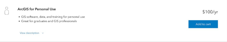
Step 2: Click on "Pricing" and select the personal version.

Step 3: Click on "Add to Cart."
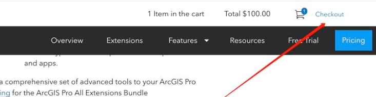
Step 4: Click on "Checkout."
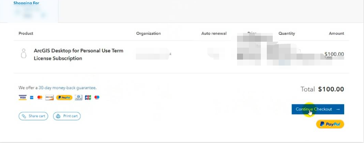
Step 5: Click on "Continue Checkout" and verify the order details.
Step 6: If paying with a credit card, enter your credit card information.
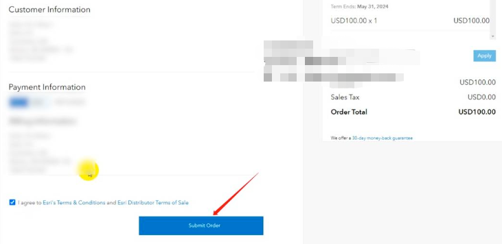
Please note that before making a purchase, you need to register an account and provide the required user information. Once the payment is successful, you will receive an email. Please check the email for a link that contains the complete instructions for installing and activating ArcGIS.
Once the payment is successfully processed, you will receive an email in your mailbox. Click on the link provided in the email to access MyEsri, where you will find comprehensive instructions on how to install and activate ArcGIS (note that the instructions will be in English). Currently, the version I purchased allows me to use ArcGIS Pro 3.1 and ArcGIS Desktop 10.8.
I hope these illustrations help you better understand the process of purchasing ArcGIS Pro. If you have any further questions, feel free to ask.
Section 3: Unleashing the Full Potential of ArcGIS Once you have successfully acquired your genuine copy of ArcGIS, it's time to unlock its vast potential and harness its transformative power. Dive into a world of infinite possibilities as you leverage ArcGIS's advanced tools and functionalities to:
- Analyze Spatial Data: Uncover hidden patterns, relationships, and insights within your geospatial datasets using ArcGIS's robust analytical capabilities. From spatial querying to geostatistical analysis, ArcGIS empowers you to extract valuable knowledge and make informed decisions.
- Visualize Geospatial Information: Bring your data to life through stunning visualizations that transcend traditional maps. ArcGIS offers a range of dynamic cartographic techniques, enabling you to create compelling representations of your geospatial information and convey complex concepts with clarity.
- Collaborate and Share: Foster collaboration and knowledge-sharing within the GIS community by leveraging ArcGIS's collaborative features. Engage in geospatial discussions, share maps and data, and participate in crowdsourced initiatives to drive innovation and expand your GIS network.
One response
[…] ArcGIS is the most professional and widely used GIS software.And How to buy it https://upgis.com/index.php/2020/06/12/arcgis-desktop%ef%bc%8carcgis-pro/ However, I’d like to introduce an alternative method that is suitable for GIS web […]